Camouflage
location: Kalmar,Sweden| size:127 ha| status:competition ![]() In biology, camouflage denotes the ability of an organism to blend into its own environment in order to avoid detection by other organisms. It is widely known about the strong evolutionary importance of the living organisms’ ability to negotiate and conceal their own shape in often opposing conditions. Of more significance to our concept is that camouflage may be understood as a method of adaptation to the environment in addition to being one of the basic survival mechanisms in nature. Now, we would like explore if camouflage may be observed as a territorial system applicable to a specific design strategy for the given site in Kalmar. The proposed system asks from the entity to simultaneously belong to two opposing worlds, or even several different pairs of contradicting worlds. Our proposal investigates the transposition of the term camouflage into realm of architecture and urban design as a strategy of spatial adaptability and as a model for the continual urban growth which provides for reconciliation between the four pairs of the opposing aspects of the given context. Firstly, camouflage is the strategy to respond Kalmar’s specific position between the land and the sea. Secondly, this is the way to find the balance between the pristine landscape and urban development. Thirdly, camouflage is a model to provide for the simultaneous need of belonging to the community and the necessity to exercise one’s own privacy. Lastly, camouflage is way to alternate between indoor and outdoor spaces and provide for a lifestyle which unfolds in both of them. The proposed strategy answers the urge to be connected and to be a part of the community while providing for the fragmentation and individuality at the same time.
In biology, camouflage denotes the ability of an organism to blend into its own environment in order to avoid detection by other organisms. It is widely known about the strong evolutionary importance of the living organisms’ ability to negotiate and conceal their own shape in often opposing conditions. Of more significance to our concept is that camouflage may be understood as a method of adaptation to the environment in addition to being one of the basic survival mechanisms in nature. Now, we would like explore if camouflage may be observed as a territorial system applicable to a specific design strategy for the given site in Kalmar. The proposed system asks from the entity to simultaneously belong to two opposing worlds, or even several different pairs of contradicting worlds. Our proposal investigates the transposition of the term camouflage into realm of architecture and urban design as a strategy of spatial adaptability and as a model for the continual urban growth which provides for reconciliation between the four pairs of the opposing aspects of the given context. Firstly, camouflage is the strategy to respond Kalmar’s specific position between the land and the sea. Secondly, this is the way to find the balance between the pristine landscape and urban development. Thirdly, camouflage is a model to provide for the simultaneous need of belonging to the community and the necessity to exercise one’s own privacy. Lastly, camouflage is way to alternate between indoor and outdoor spaces and provide for a lifestyle which unfolds in both of them. The proposed strategy answers the urge to be connected and to be a part of the community while providing for the fragmentation and individuality at the same time.  Ten fingers within strategic site, Scale 1:30000 In-between the land and the sea The question posed is how we can establish connections between the existing urban fabric and the sea shore with the insertion of the new housing programme. The proposed strategy suggests formation of 5 within the project site, and 10 within the strategic site, finger-like connections cutting across the existing road E22 and leading form the existing housing at Rinkabyholm to the sea shore. In the gradual process of the development, they are initially conceived as routes of pedestrian circulation which hold the potential to become main access lines for the new housing development. This intervention is to coincide with the planned reduction in the traffic volume along the present route of the road E22. The new front of what is to be the former road E22 will be the patchwork of woodlands and built zones positioned where the “fingers†begin and in accordance with the urban fabric of Rinkabyholm. The intention is to activate the street front to support its conversion from the road to the local street. At the same time, we propose formation of continual stretches of woodlands parallel to the existing road E22 and cutting across the previously described finger-like connections linking the urban fabric and the sea. The resulting matrix is the footprint of the new development which provides for the simultaneous continuity and discontinuity of the existing landscape and a camouflage of the new housing development into the natural surroundings between the land and the sea.
  Belonging to the City and Belonging to the Landscape, Scale 1:10000
 Transversal and Longitudal: new streets connecting city with the shore and recreational paths
  Five fingers within project site, Scale 1:5000 In-between the pristine landscape and urban development The question posed is how can new housing take place and connect to the pristine landscape without spoiling it? The proposed housing clusters are distributed along the finger-like routes leading form the existing housing at Rinkabyholm to the sea shore. The room between the clusters is occupied with the continual stretches of woodlands as described in the previous paragraph. Each of the proposed clusters is designed as a swelling along the access route and contains approximately 15-20 residential units. Such configuration provides each unit with the simultaneous access form the road and the direct connection to the woods. This is an important contrast in comparison to the individual housing typology found at Rinkabyholm, whereby units have no direct access to woodlands. The proposed spatial organization suggests intertwined relationship between the natural landscape and the built environment. The entire process of the urban growth according to the camouflage strategy is seen as a gradual and adaptive affair which may unfold simultaneously at different scales. Firstly, previously described “fingers†may be created one by one; secondly each of them could grow from the road toward the sea shore line through the gradual addition of clusters; and finally each of the clusters could enlarge incrementally with the addition of individual units until the assigned number is met.
  Dynamic expansion of Rinkabyholm
  Street phase development within the site and Cluster development within new streets In-between private and communal The question posed is how to provide for the simultaneous need of belonging to the community and the necessity to exercise one’s own privacy. The proposed density of the housing development multiplies the existing one at Rinkabyholm. Elongated footprint of the gardens belonging to a single group comprised of up to four (three at the ground level) individual housing units allows for the increase of the density whiteout any compromise of the quality assumed by the individual housing typology. Yet, no fences are planed and all housing units belonging to the same cluster will inevitably form social bonds typical of every successful neighborhood. The intention is that area inbetween homes belonging to the same cluster will be left open but clearly comprised of individual allotments. This space is conceived as individual and communal at the same time and inspired by the Swedish Right of Common Access which guarantees the possibility of passing through or remaining on someone else’s land and may be traced back to the provincial laws of the 13th century. These fundamental rule could still apply today to help better interaction between the residents and the nature.
 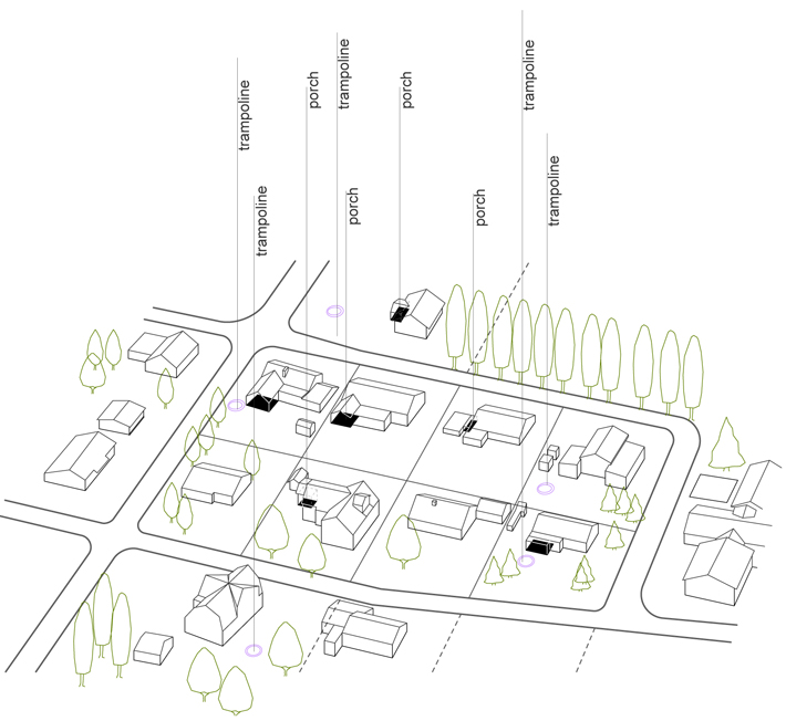 Structure of RiInkabyholm dwellings: separate playgrounds and porches
  Proposed “cluster†dwellings with flexible structure and possibility of growth: collective playground and integrated porches encourage outdoor lifestyle
  Cluster development within new streets, Scale 1:2000 In-between indoor and outdoor The question posed is how to create housing development providing for the lifestyle which unfolds both in indoor and outdoor spaces. In addition to size of the units, housing typology is determined with the relation between indoor and outdoor spaces. Each unit has its own outdoor room, a porch which may be attached to indoor space in several different ways named: cut, bite, split, pinch, narrow and slice. When combined together, two or more housing units also form additional outdoor space which is shared between the forming units. This may be done in three different ways named: small, medium and large. The resulting pattern of individual and communal porches provides for the multiple and layered relationship between the private and communal as well as indoor and outdoor spaces.
 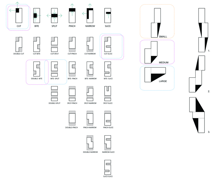 Private porch typology within single unit: Cut, Bite, Split, Pinch, Narrow, Slice; Colective porch typology with floor plan variation: Small, Medium, Large; Growth pattern in floor plan up to three units;
 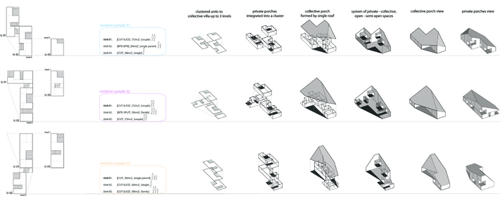 Clustered units to collective villa up to 3 levels
  System of social interaction within one dwelling cluster
credits///design: 4of7///Ivana Damjanovic, Djordje Stojanovic, Milutin Cerovic ///
